.

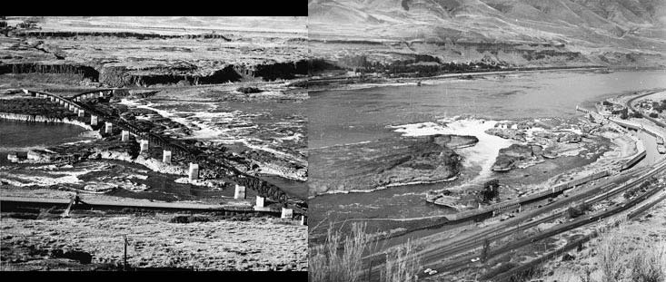
Benjamin Gifford, photographer. OrHi # 89622
The photographer, Benjamin Gifford, operated a photograph studio in The Dalles from 1895 to 1910.
.
The Heart of the Southern end of our Cascadian Bioregion for the last 12,000 years or more has been Celilo Falls – also known as Wyam – meaning “echo of falling water” or “sound of water upon the rocks.” The falls could be heard by a traveler well before they could be seen – from over a mile away. This site is the heart of one of the most productive historic fisheries, trade and cultural centers of Turtle Island. The falls are intact under Lake Celilo, an artifact of the US Army Corp of Engineers and the Dalles Dam. Lake Celilo submergeged the Celilo Falls on March 10, 1957. The Corp has admitted that the dam was an act of cultural genocide and knows the falls should be returned to the people. We now know this could happen immediately, before removal of the dam, keeping the ability to generate electrical energy until the dam is removed.
But first a little bit of background information.
************************
The National Bison Range (Where the largest surviving herd of Buffalo were and are protected) in Montana is on a mountain that was an island in Lake Missoula.
At the end of the last ice age – 12,000 years ago, the lake broke several times and according to the geologic record formed the CheeAwana / Columbia Gorge as we now know it. The Willamette Valley had a 400 plus foot wave pass through!
****************************
English is the dominant language currently spoken in the region, a language which was spoken in this landscape for the first time 221 years ago when Capt. Gray first came into the Columbia River. He renamed the CheeAwana for his boat the Columbia Rediviva on May 18th, 1792.
Up the CheeAwana here in Oregon is Celilo Village which has been continuously occupied for over 11,000 years – some radiocarbon dates suggest even older occupation of the site, which makes it the oldest documented continuously occupied village site in North America.
Our First Nations people consider English Speakers as babies in this landscape from this ancient perspective of cultural experience.
************************
These are the greatest falls in our region. The quantity of fish which historically have been caught there facilitated the feeding of huge annual gatherings that have been the center of regional trade in networks that have been documented to go across the continent to Florida and as far south as Patagonia. The waters and the salmon are not viewed as commodities but rather as medicine. Today many of these medicinal qualities of the waters have been weakened through the addition of radioactive and chemical pollution from the military and poorly regulated commercial agriculture and industry.
If you would like to see panoramas contrasting before and after flooding – please visit the Oregon Historical Society Historic Viewer, a powerful comparison tool.

*******************************
Our First Nations have preserved Rights that other peoples have forgotten or surrendered. These rights come from their Indigenous Title to the land – much of which was surrendered under the duress of genocidal violence by the United States Government. These rights include the right to hunt and gather traditional foods in their historical indigenous territories – to obtain the sources of life without the use of money.
We have discovered that the Dalles Dam can operate at near full electrical capacity with the slackwater lowered to levels that fully restore an intact Celilo Falls.
The only reason the falls are continuing to be flooded may be to facilitate commercial industrial barge traffic. Last year this traffic was closed for 4 months to undergo over $50 million dollars in taxpayer subsidized repairs to the locks. Commercial traffic of commodities and garbage was done with alternate forms of transport with no significant cost to the affected industries. Barge traffic is only possible because of huge publicly funded subsidies, degradation of salmon habitat, and multiple other lost opportunity costs. An engineering study is currently being done at PSU to work out details of potential recovery scenarios.
The return of a UNESCO World Heritage quality regional site will restore a planetary treasure to our region and invite repair of relations between our First Nations and all of us who find ourselves at home here in the Northwest. It must be done with the guidance of the First Nations who are the spiritual guardians of the falls. Celilo’s return will also significantly improve the restoration of Salmon, the key indicator species of our entire bioregion.
This is the first in a series of explorations of Celilo Falls and it’s emerging respectful return.
A Short Video of Fishing at the Falls before the Flooding
.


I am interested in donating to the celilo community near cascade locks jackestes@comcast.net